Rest in Peace Peter Harlem, Sea Level Rise Scientist, Geologist, and GIS Pioneer
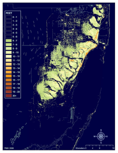
Map by Peter Harlem
I am sad to learn that Peter Harlem, GIS coordinator at Florida International University, died today. Peter was an innovator in many respects including his creation of LiDAR maps of South Florida flooding that are today widely used to illustrate what will happen to our state as seas rise in the decades to come.
Peter was also one of the very first people that I contacted when I began researching climate change and sea level rise. He was gracious beyond belief in sharing his knowledge with me, then just a 15 year old child, and I will never forget the time that he took to explain how he created his maps, as well as our wide ranging discussions on numerous topics ranging from the Everglades, his work in Biscayne Bay, his concerns over Turkey Point, and many others. When I asked if he would share his maps with me, he eagerly stood up from his chair, walked from behind his desk, and insisted that I sit in his place and download anything that was of interest to me.
I am sad to learn of Peter’s passing, but I am truly honored to have known him. As, perhaps, a very small homage to his legacy I am proud to have used several of his maps in my recent TEDx talk, one of which I have attached here today as a memorial to just a small bit of his work.
Rest In Peace Peter and thank you for what you have done for all of us.
